Monday, March 26, 2018

FREE, NO COST (except travel & lodging) Training Offered . EPA Environmental. State, County, City, Township, and Federal Employees.

Keep in mind that all incidents and disasters are local until federal response or other coordinating entity arrives on scene.
Have someone familiar in your local office at the State, County, City, township familiar with environmental Superfund process for the protection of your community. 
Don’t wait until the event occurs, get ahead of the curve.
BEMA International


** Attendees must be Federal, Tribal, State or Local agency employees. 
   
     Contractors, private industry and academia are not permitted to attend
    either course.  Travel/lodging costs are the responsibility of the student or
    student’s employer. **

Oil Response Training - Combined Backwater and Fast Water
Hosted by Environmental Response Training Program (ERTP)
ERT – OSRTI
Portsmouth, NH
April 16, 2018 - April 19, 2018
Password:  cosmo1
This course is custom designed to meet requests of U.S. Environmental Protection Agency (EPA) Federal On-Scene-Coordinators (FOSCs) in their regions. The course may be from 2 days to 5 days in length dependent on request and agenda development. The course may contain any of the course content and field work found in the Slow, Backwater Practical Course or Fast Water Practical Courses listed in their course descriptions. Dependent upon selection of course work participants will deploy boom on lakes or rivers; establish oil recovery sites; provide protection to sensitive areas and shoreline with boom; operate boats on lakes or rivers; install dikes, dams and filter fences on streams; and install French drains and cut-off walls.
Instructional methods will include classroom instruction and field work.

Introduction to Risk Assessment Guidance With Expanded Eco-Risk
Hosted by Environmental Response Training Program (ERTP)
ERT – OSRTI
Augusta, ME 
May 15, 2018 - May 18, 2018 
Registration:  https://trainex.org/classdetails.cfm?courseid=1561&classid=7759
This 3.5-day course provides participants with the fundamentals of risk assessment as applied to the Superfund cleanup process. This course is designed to present an introduction to the Superfund risk assessment process to Project Managers, On-Scene Coordinators, Risk Assessment Reviewers, and potentially new Risk Assessors working at hazardous waste sites or treatment, storage, and disposal facilities. The course assumes little experience with toxicology and risk assessment or knowledge regarding Superfund risk assessment guidance.

Waste Treatment, Transportation, and Disposal
Hosted by U.S. EPA
Office of Superfund Remediation and Technology Innovation
Boston, MA
June 6, 2018 - June 7, 2018
Waste Treatment, Transportation and Disposal, a 2-day advanced training course, focuses on specific technical and regulatory issues that On Scene Coordinators (OSC) and Remedial Project Managers (RPM) must address when treating, transporting and disposing of waste.
 

Massive Oil Fields in Texas Are Heaving, Sinking, And Opening Up Like Mouths

Massive Oil Fields in Texas Are Heaving, Sinking, And Opening Up Like Mouths
https://www.sciencealert.com/massive-oil-fields-in-texas-ar…

4,000 square miles of geohazard.
PETER DOCKRILL
22 MAR 2018

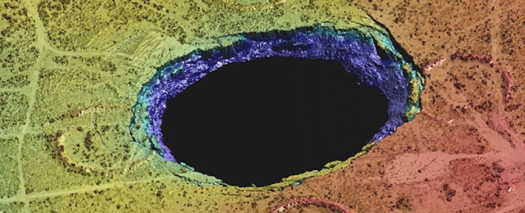
It began with sinkholes. Two of them, gaping mouths to nowhere opening up as if to swallow the town of Wink, Texas. As they expanded, there were fears they might collide, morphing into one giant void.

They first emerged in 1980, and things haven't gotten better since. Now, an unprecedented study reveals Wink and its vast sinkholes are just a tiny part of a much bigger problem – a vast stretch of historical oil fields that are heaving and sinking, covering an area almost the size of Connecticut.

"The ground movement we're seeing is not normal," explains geophysicist Zhong Lu from Southern Methodist University in Dallas.

"The ground doesn't typically do this without some cause."

235 texas oil wink geohazard 3Safety sign in Wink (Nicolas Henderson/Flickr)

Lu was part of a team who in 2016 used satellite data to reveal that the two Wink sinkholes weren't frozen in place, but could be about to expand in response to subsidence detected in and around the town.

Now, the researchers have used the same techniques, zoomed out, to find that an area encompassing some 10,360 square kilometres (4,000 square miles) – covering four counties and six towns – is in fact sinking and uplifting, in parts by as much as 1 metre (40 inches).

"These hazards represent a danger to residents, roads, railroads, levees, dams, and oil and gas pipelines, as well as potential pollution of ground water," Lu says.

"Proactive, continuous detailed monitoring from space is critical to secure the safety of people and property."

The satellite data the team used was sourced overhead in between November 2014 and April 2017, and coupled with oil-well production data provided by the Railroad Commission of Texas, the researchers conclude this epic instability is the result of decades of oil extraction in the area, and its knock-on effects on rocks below the surface of the earth.

235 texas oil wink geohazard 3Ground deformation (Zhong Lu and Jin-Woo Kim/SMU)

Nobody's sure quite how the heaving and sinking will develop from here, but the bad news is the phenomenon might not be contained to the already vast expanse of oil fields the researchers have so far looked – the extent of the damage could ultimately be way bigger.

"Our analysis looked at just this 4,000-square-mile area," says one of the team, geodetic scientist Jin-Woo Kim.

"We're fairly certain that when we look further, and we are, that we'll find there's ground movement even beyond that. This region of Texas has been punctured like a pin cushion with oil wells and injection wells since the 1940s and our findings associate that activity with ground movement."

The subsidence issues – which are thought to be tied to seismic activity that's previously been linked to oil and gas operations in Texas – will be monitored ongoing by the team, who want to know how bad the problem is, and how far it reaches.

"We have seen a surge of seismic activity around [the town of] Pecos in the last five to six years. Before 2012, earthquakes had not been recorded there," Kim says.

"Although earthquakes and surface subsidence could be coincidence, we cannot exclude the possibility that these earthquakes were induced by hydrocarbon production activities."

There's a lot more research to be done before we understand the full extent of this heaving landscape, but it sure looks like a legacy of plunder spanning most of a century has left the ground under Texas disturbed, even famished, and the time has come where it wants something back in return.

The findings are reported in Scientific Reports.


National Latino Farmers & Ranchers Trade Association 
1029 Vermont Avenue, NW, Suite 601
Washington, DC 20005
Office: (202) 628-8833
Fax No.: (202) 393-1816
Email: latinofarmers@live.com 
Twitter: @NLFRTA
Website: www.NLFRTA.org 

RECOMMENDED READING LIST

Search This Blog

ARCHIVE List 2011 - Present